Use of the Tidal Thames: A Practical Guide for Local Authorities and Developers
This document is also available as a PDF.
The purpose of this document is to enhance the development of the tidal River Thames (“the Thames”) and assist local authorities and developers when they are preparing and assessing development proposals on or adjacent to the Thames. It also provides details on the topics that need to be taken into consideration at an early stage when developing within the unique environment of the Thames to help shape developments alongside or on the river, to enhance their connection with the water.
Robust consideration of these topics will help ensure developments are in line with the priorities of the Port of London Authority’s (PLA) Thames Vision 2050 plan. The PDF at this link provides a summary checklist of all the topics included in this guide and further detailed information on each topic can then be found throughout the remainder of this guide. This document provides a summary checklist of all the topics included in this guide and further detailed information on each topic can then be found throughout the remainder of this guide.
The PLA can provide advice and guidance throughout the planning stage of a development proposal. In the first instance please contact Michael Atkins, Senior Planning Officer on [email protected] or 01474 562305.
The Port of London Authority
The PLA is the statutory harbour authority for the tidal Thames, running for 95 miles from Teddington Lock in West London to the North Sea. The PLA manages the UK’s busiest inland waterway for passenger travel and freight movements. There are over 70 wharves and terminals across the area. In 2021, 51.8 million tonnes of freight was handled within the Port of London, the most cargo of any UK port.
As a Trust Port, through its activities and the regulation of others the PLA are committed to leaving the Thames in a better state than we received it, and we provide information, support and technical expertise to help river users and investors maximise the use of the river. The PLA works with a wide range of stakeholders and partners on various matters including conservation, safety, leisure, sport, commercial freight, property and passenger transport.
As stewards of the marine environment, the PLA carefully protects and improves the environment for wildlife, keeping the river clean and free of rubbish. We also support the use of the river as a low-carbon solution for the south east of England, while continuing to respond to the climate impacts changing the river and the port. We act as an environmental leader in the UK ports industry and in 2018 were the first harbour authority to develop and publish an evidence-based Air Quality Strategy. Updated in 2020, the strategy and actions continue to be implemented with key stakeholders within the port.
In terms of landownership, the PLA owns and has the responsibility for approximately 90% of the riverbed and banks of the tidal Thames up to the Mean High Water (MHW), with the remainder owned by the Crown Estate and private landowners.
All planning decisions that relate to the UK marine area which includes the tidal Thames must consider the Marine Management Organisations (MMO) South East Marine Plan (2021), which conforms to the Marine and Coastal Access Act 2009 and Marine Policy Statement requirements with regard to any development within the marine environmental.
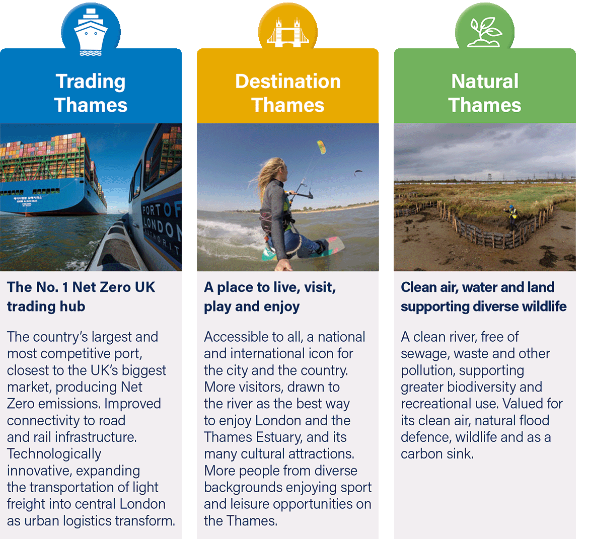
The Thames Vision & Shared Objectives
The Thames Vision 2050 is built around three interconnected themes, centred on the role the river plays for people and the environment:
In London the Thames Vision priorities are in line with the Mayor’s London Plan, and associated Transport and Environment strategies and align with over 90% of local authority Local Plans, across the PLA’s navigational jurisdiction. (The remaining 10% due to the timescales in the preparation of Local Plans). The PLA sits on the Thames Estuary Growth Board and its action plan The Green Blue, is consistent with the Thames Vision goals, providing a focus on investment in and use of the river from London to the outer estuary.
The PLA will also sit on the Thames Freeport board which has the aim to achieve a digitally-linked economic zone connecting Ford's world-class Dagenham engine plant, the global ports at London Gateway and Tilbury, large development employment areas and many river communities in need of regeneration.
 This all highlights how the tidal Thames can play a central role in meeting wider economic, social and environmental objectives, including the priority of the net zero transition and supporting a green recovery. See our Action Plan, which highlights how we are delivering on the Thames Vision. Our Thames Vision 2050 aims to create the UK’s leading port, central to the nation’s economy, with Net Zero emissions. A clean river, free of pollution and rubbish, supporting more sport, passengers and freight. A resilient Estuary, adapting to climate change and richer in wildlife. A more diverse Thames, providing jobs, learning and enjoyment to the whole community, and always, everyone, staying safe. |
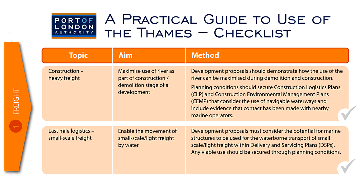
1. Freight
There are two key aspects with regard to freight transportation that must be considered for planning applications which are located in close proximity to navigable waterways.
 The Thames is the UK’s busiest inland waterway, a low-carbon transport option, keeping lorries of the capital’s congested roads. |
-
Construction – Heavy Freight
Currently around 90% of freight in London is moved by road. The tidal Thames provides an excellent option for modal shift providing a sustainable transport option for construction and waste materials across London, Kent and Essex. Where roads are already congested and air quality is poor, the use of the river as an alternative means of transportation can play a key role in improving these issues and help improve road safety, lower the carbon footprint of a development and provide a solution for abnormal loads. Use of the River in this way is supported by national, regional and local planning polices and every million tonnes carried by water can take over 100,000 lorry trips off the roads. See Growing the UK inland water freight sector- Lessons from the Thames.
Construction materials and waste can be transported on the river to serve development and infrastructure projects close to the river, either directly to/from a development site or through the supply chain by using a nearby wharf or landing facility.
The PLA welcomes planning applications which consider the use of the river. Where applications require the production of Construction Logistics Plans (CLP) and/or Construction Environmental Management Plans (CEMP) the PLA recommends that planning conditions clearly set out the requirement for these plans to consider the use of navigable waterways. Furthermore within detailed CLPs and/or CEMPs; it is recommended that information is provided on the contact that has been made with nearby wharf operators on the sourcing of materials from their facilities and/or the use of their facilities as part of the construction and demolition stages, which can allow related planning conditions to be discharged.
The Water Freight Toolkit contains information on barge operators, operational wharves and guidance for incorporating the river into CLPs and/or CEMPs. See the toolkit for more.
-
Last Mile Logistics – Small-Scale Freight
There is an opportunity to utilise existing marine infrastructure to enable the movement of small-scale/light freight by water. This would significantly reduce the need for road-based delivery vehicles, reducing traffic levels, road danger and improving air quality. For development proposals located near to navigable waterways, it is recommended that at an early stage these consider the potential utilisation of this infrastructure for small scale freight, in co-ordination with stakeholders including the PLA. To further support this Delivery and Servicing Plans (DSPs) should include information on how the multi-use of wharves, piers, jetties and other landing points has been considered, and if a viable use is recommended, this should be secured through an appropriately worded planning condition.
There is also potential for freight facilities on riverside sites to be combined with electric vehicles/cargo bikes/walking to improve air quality and reduce congestion through the creation and use of micro consolidation hubs for local areas. This approach to logistics is set to grow to help meet changing patterns of demand and the river can play a large part in helping to achieve this change. The PLA is working with the GLA, the Thames Estuary Growth Board, Cross River Partnership and other partners to develop light freight logistics on the Thames.
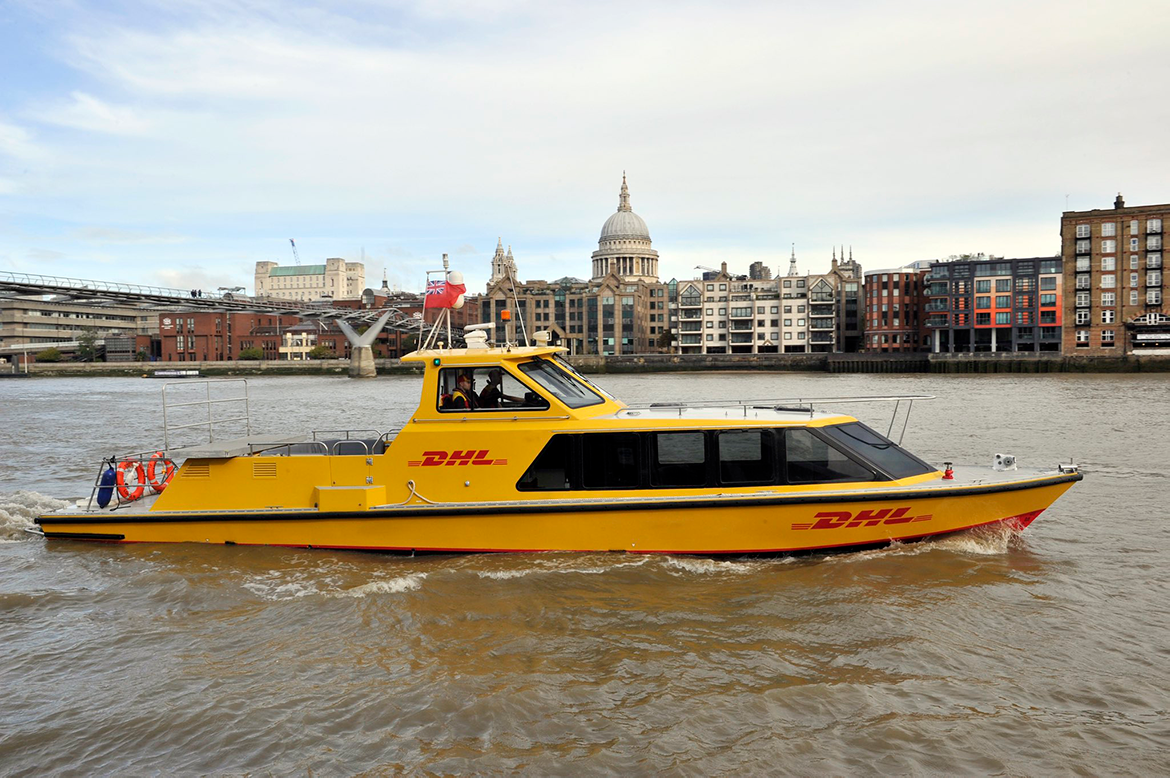 The City of London Corporation has developed plans to consolidate and relocate three historic wholesale food markets (Smithfield, Billingsgate and New Spitalfields) to a new 42 acre site in Dagenham Dock. To combat concerns over additional congestion on road networks, including the A13, the use of the tidal Thames will form a key part of the transport aims for the project for the transportation of produce. Another example is DHL’s use of the Thames to provide an express parcel delivery service, with courier bicycles used for final mile delivery from Bankside Pier. |
2. Safeguarded Wharves
There are a number of wharves and terminals located along the tidal Thames many of which operate up to 24 hours a day. These are protected for waterborne freight cargo-handling through local and regional planning policy. In London specifically, 43 wharves are protected by 2021 Safeguarding Directions issued by the Secretary of State for Housing, Communities and Local Government and supported by associated London Plan policy SI 15.
In Kent, wharves are safeguarded through the Kent Minerals and Waste Local Plan 2013-30 (2020) and supported by local planning policies. In Essex, wharves are safeguarded through local plans, the Essex and Southend-on-Sea Waste Local Plan (2017) and the Essex Minerals Local Plan first review (1996).
 The Peruvian, Plaistow and Royal Primrose safeguarded wharfs form part of an industrial cluster in Newham, East London. |
The PLA is actively engaged with the Mayor of London, Local Planning Authorities, and other stakeholders to ensure the continued protection and reactivation of safeguarded wharves for waterborne cargo handling. The PLA also seeks to protect safeguarded wharves from inappropriate development on nearby land which could result in adverse impacts on their operations.
In addition to safeguarded wharves, there are also a number of operational boatyards located along the tidal Thames. These are essential for servicing passenger and other vessels and are protected by planning policy. This essential waterway support infrastructure must also be taken into consideration when development is proposed in close proximity to them.
When development proposals are situated in close proximity to safeguarded wharves or other operational sites, early contact should be made with the PLA to ensure that the assessments required to support an application (such as noise, vibration and air quality assessments) fully assess and mitigate the potential impacts that prospective new users of a development may experience due to the operations at these sites. As part of these assessments, particularly for noise, it is important to consider:
- The potential for wharves and operational boatyards to operate for 24 hours a day throughout the year, in line with the tides, therefore it is essential that assessments measure day and night time activity.
- The required noise assessments must be undertaken using British Standards BS 8233 (Guidance on sound insulation and noise reduction for buildings) and BS 4142 (Method for Rating Industrial Noise Affecting Mixed Residential and Industrial Areas). The noise rating levels must be determined using BS 4142 and then compared to the background sound level (BS 4142) and the guideline values (BS 8233). This must account for the nature of the noise (tonal, intermittent etc) and correct the assessed noise level in order to determine the ‘rating level’. Only once this assessment is complete can appropriate mitigation be identified and conditioned.
- In addition, it must also be made clear within the required assessments that all types of potential noise have been taken into account, including low frequency noise from dredging operations, which can occur at some safeguarded wharves at any time over a 24 hour period.
- The need to contact nearby operators to confirm that the time periods for a proposed assessment would capture a ‘typical’ operating period for the wharf and/or boatyard. Discussions should also be held with the operator to understand what activities might reasonably be expected to take place at the site in the future so a reasonable worst case scenario can be assessed.
There are examples of successful residential development adjacent to wharves, such as Greenwich Millennium Village where sound reduction was designed into the scheme.
|
The GMV site is located on Greenwich Peninsula in an area that has been allocated for 700 jobs and a minimum of 13,500 new homes. Approximately 30 metres from the development are two of Europe’s largest marine dredged terminals, the Safeguarded Angerstein and Murphys Wharves. Between 2012 – 2016 the wharves handle between almost 3 million tonnes of aggregate per annum and provide 40% of the London’s supply of aggregates. The design of the GMV scheme accepted that as part of the residential development there was a need for a substantial screen along the boundary between the development site and Wharves. This resulted in a scheme with corridors and storage spaces along the boundary with the wharves and residential properties that look out over the river away from the wharves. The development process highlighted the need for early and proactive engagement between residential developers, wharf operators, the Local Authority and the PLA in order for there to be a full understanding of the operations that take place at a wharf and the impact that would be experienced at the nearest residential receptors. Another important aspect of the development was the need for robust noise modelling to be undertaken, which was able to determine the size and specification of windows and whether they should be openable or not. To date no noise complaints have been received from residents with regard to the wharf operations. |
 Case Study: Greenwich Millennium Village (GMV)
A variety of mitigation measures are available to prevent adverse impacts including impacts from noise, odour, vibration, air quality and highways access, and the need for this to be addressed as part of new development proposals is set out in planning policy through, included in paragraph 187 of the National Planning Policy Framework (2021), which places the responsibility of mitigating the impact of noise from existing noise generating businesses, such as wharf operations, on the proposed new development close by. This is also reflected in planning policy including policy D13 (Agent of Change) of the London Plan, the Kent Minerals and Waste Local Plan Safeguarding Supplementary Planning Document (SPD) (2021) and recently adopted Local Plans. This principle helps to ensure that potential future residents and existing and potential wharf operations are both protected.
It is essential these assessments are completed at an early stage, to enable any required mitigation measures to be incorporated into the detailed design of a development. Potential mitigation measures could include:
- Ensuring habitable rooms such as bedrooms do not directly overlook an operational facility;
- The incorporation of different glazing requirements for windows;
- The requirement for winter gardens and/or the fixing shut of windows.
The PLA continues to work proactively with all stakeholders to achieve the aims of the Thames Vision to ensure the reactivation and maximisation of use of all safeguarded wharves within the PLA’s jurisdiction. Any parties considering developments in close proximity to this vital infrastructure are encouraged to contact the PLA an early stage.
3. Passenger Transport and Piers
A number of new passenger piers are being introduced along the tidal Thames most recently at Royal Wharf Pier in Newham and Barking Riverside in Barking and Dagenham and there are also opportunities for the extension of river services to continue eastwards into Kent and Essex. These provide a valuable addition to public transport infrastructure for communities and visitors, particularly when combined with good pedestrian and cycle access, and links to other forms of public transport.
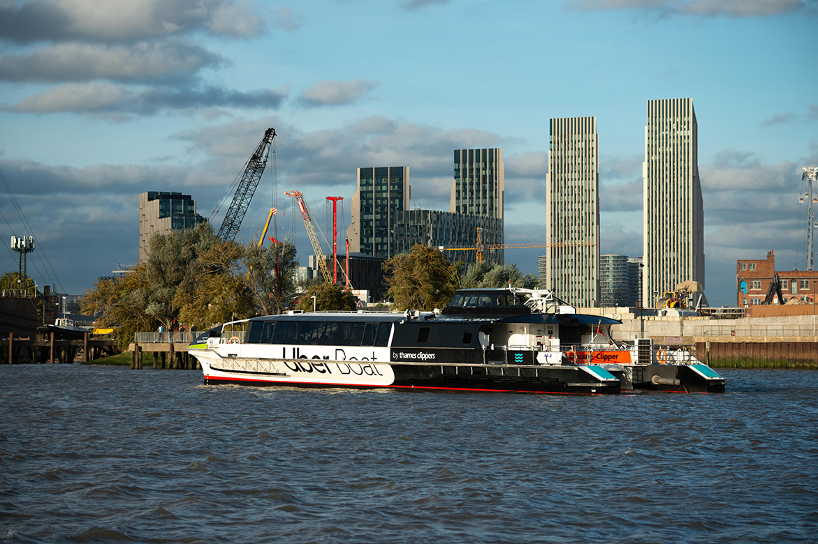 Daily scheduled passenger services now operate along 20 miles of the Thames, from Putney to Barking Riverside. |
Charter vessels also operate throughout the tidal Thames for both residents and visitors to London and the south east and there is a need for additional berths for such vessels.
Early discussion with the PLA can help shape the development of any new piers or jetties and provide guidance developers. Examples include accessibility standards for new piers, understanding the impact of tides and the depth of water, and ensuring structures do not extend too close to the navigable channel.
The PLA can also assist in identifying key environmental considerations and suitable mitigation measures, for example the provision of green technologies and habitat enhancements. Future considerations should include access during extremes of weather, flood walls requiring raising, and the provision of fuel for low emissions vessels.
Transport connectivity should also be considered including integration with bus, rail, road, cycling and walking networks. There are also opportunities for the extension of river services to continue eastwards into Kent and Essex, particularly given the increasing development and population growth expected throughout this region.
Transport Assessments and Travel Plans for new developments should demonstrate that existing and proposed river bus services have been fully considered, including providing targets for promoting increased use of these services. Often new developments are accompanied by Travel Information Packs which provide information to new residents on nearby public transport locations and timetables and it must be ensured that river bus service information is included as part of these.
Developers and pier owners should also consider a range of uses for piers, such as allocating berths or timed access for river tours, chartered services or recreational uses to support the local visitor offer and associated economic benefits. In London TfL’s Passenger Pier Strategy (2019) promotes the potential for the multi-use of piers, including small-scale freight, to further help promote modal shift from road to river. It is recommended that the use of the river in this way is considered as part of associated Delivery and Servicing Plans for appropriate developments and this should be specifically highlighted as a requirement within associated planning conditions.
4. Thames Path & Riverside Public Realm
The Thames Path National Trail, England Coastal Path and other riverside spaces should be accessible to the public and inclusive in nature. Any proposed development which includes these areas must provide details of access ways and routes to the riverside for the benefit of both new and existing communities. If there are gaps in the existing riverside path, these should be closed where possible, and the provision of additional routes should factor into the design an extreme tide escape route should this be close the river edge.
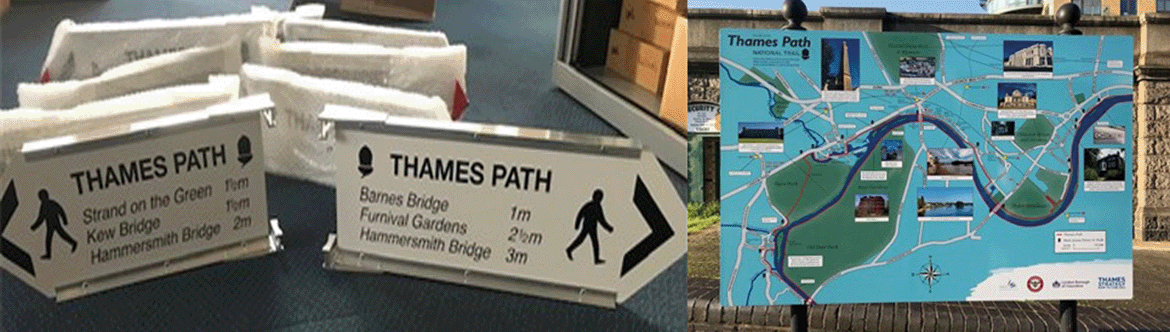 Clear signage is an important part of riverside developments. |
There can be particular challenges in finding the best access route near wharves and terminals. This requires pragmatic solutions that achieve appropriate, safe public access, taking into account safety, regulatory and operational requirements.
Local Authorities and developers must also consider and promote access to the Thames Path and riverside areas through the development of wider master plans to ensure that not only developments located directly adjacent to waterways, but also other, nearby developments can access the riverside. Signage is also a key consideration in the enhancement of these routes.
As part of any riverside public realm proposals it must also be ensured that litter is prevented from falling into the river and there should be a maintenance strategy provided via planning condition for riverside areas which includes details of how litter will be managed, in line with the PLA's Thames Litter Strategy and to help achieve the target of the PLA’s Cleaner Thames Campaign to get 75% of the Thames Foreshore graded B or above (predominantly free of litter) by 2022.
Within London there are a number of Thames Policy areas and associated Thames Strategies which cross local authority boundaries and seek to ensure that various marine based environmental, historic and cultural topics and deficiencies are identified. These include water-based passenger, tourism and freight transport; sport, leisure and mooring facilities; marine support infrastructure; and inclusive access and safety provision. The Case for a Cultural Vision for the Thames in London was also published in 2019. Development proposals within these areas should consider these strategies and demonstrate how the development is looking to address any identified deficiencies or enhance existing infrastructure / provision. Development proposals in Kent and Essex should also consider opportunities to enhance existing provision and address any deficiencies identified through Local Plan policies.
|
In September 2020 the PLA published A Safer Riverside; guidance to assist those responsible for areas alongside or on the tidal Thames in preventing an unplanned entry into the water and assisting the safe rescue of individuals who are at risk of drowning. It includes design guidance on edge protection, lighting, and signage as well as detailed information on riparian life saving equipment (such as life buoys, grab chains and escape ladders) that should be provided as part of all riverside development. This guidance includes a series of recommendations which must be considered as part of all development alongside or on the tidal Thames and it is recommended that this is used when developing planning conditions to ensure development proposals are fully compatible with their riverside setting. |
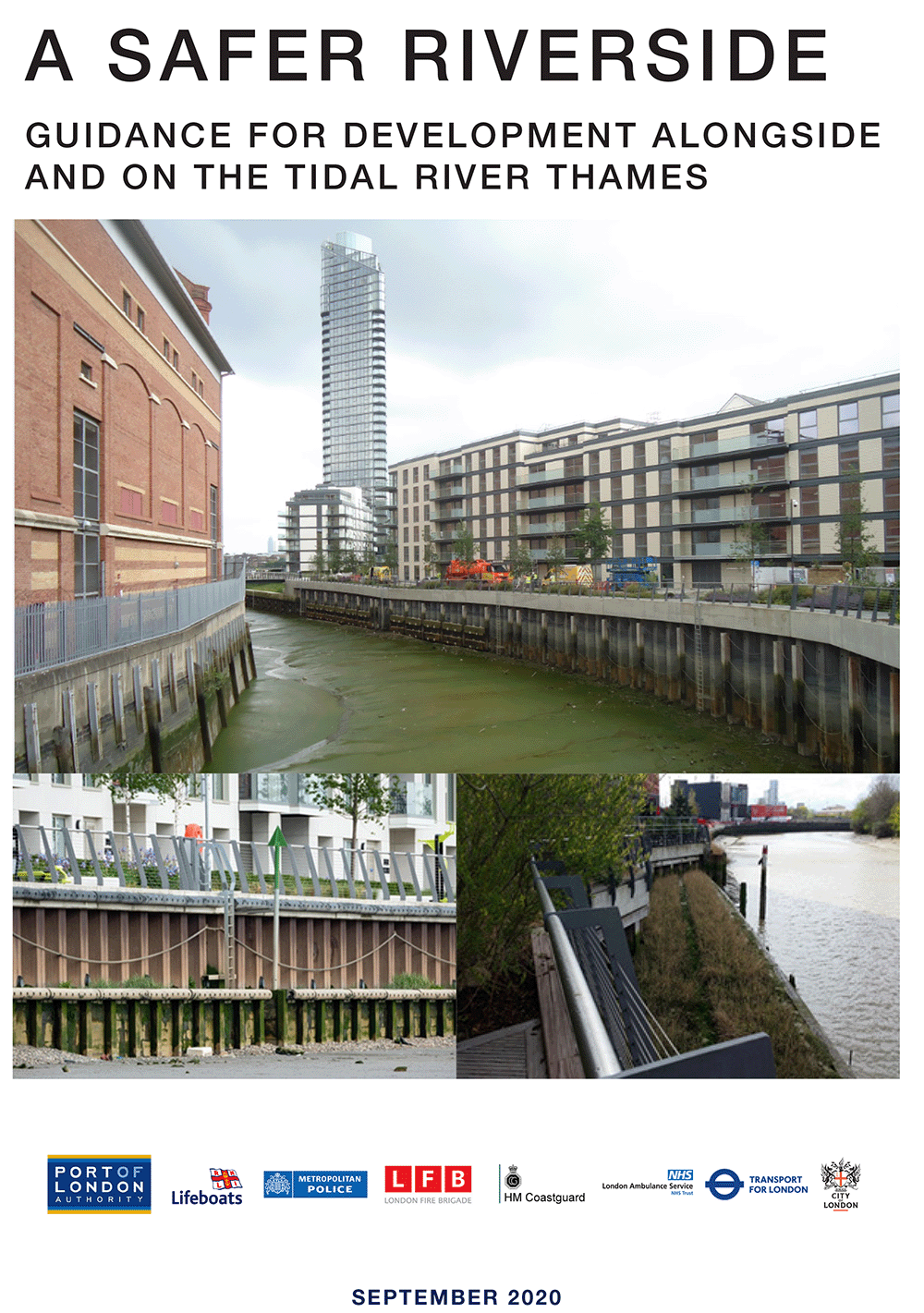 A Safer Riverside
5. Access to the Foreshore
The foreshore is used as a means of access for recreational boating and foreshore exploration, and in many areas is also frequently accessed for group litter picks (See Cleaning the Thames). Searching of the foreshore is a popular activity and the PLA provides permits for all searching, metal detecting, ‘beachcombing’, scraping and digging. (See Thames Foreshore Permits).
 The Thames is the heart of British rowing. |
Every year the Police, Fire Brigade, RNLI and London Ambulance Service rescue people who have become trapped on the foreshore. London Coastguard is responsible for the co-ordination of all search and rescue incidents by the emergency services.
There must be safe and accessible exit points for people to use in an emergency, along with the provision of appropriate life-saving equipment (See A Safer Riverside). There are multiple locations where the general public can access and exit the foreshore by using historic access points, including steps, stairs and slipways. These access points are often privately owned and do not fall under the responsibility of the PLA with regards to their upkeep and maintenance.
Development proposals which include an existing landing point or propose a new access to/from the foreshore must demonstrate how the access will be maintained and incorporated into the development, particularly as a means of escape from the river.
6. Community-focused developments:
Making the most of riverside locations can involve developing facilities to promote safe engagement with the Thames by communities and visitors. It is therefore important for any development proposals on or over the tidal Thames to primarily be for water related uses or to support the enhancement of existing water-related uses and any ancillary uses (such as a bar or café) should enhance the principal water-related use. Within London, Policy SI17 (Protecting and enhancing London’s waterways) of the London Plan specifically states that waterways should not be used as an extension of developable land, and the PLA considers that this is a relevant consideration for any proposed development across the entire tidal Thames.
 An estimated that 19,000 people use the tidal Thames for recreation each year. |
Sports facilities
The tidal Thames hosts the equivalent of over 15,000 football pitches of space. Sailing, stand-up paddleboarding, rowing and canoeing are actively encouraged on the tidal stretch and are part of the history and culture of the Thames. A study conducted by London Sport in 2017 estimated that 19,000 people use the tidal Thames for recreation each year, with scope to double this figure. Best practice examples for the river include multi-use watersports facilities which host more than one sport and/or club, with activity sessions openly available to the community.
The PLA are working with London Sport, National Governing Bodies and others to expand upon the potential of the river via the Active Thames Partnership. This partnership can be approached in order to understand the sporting needs and potential for the river, as part of pre-application advice.
Sport England’s planning guidance Active Design, supported by Public Health England highlights 10 key principles, all of which can be applied to maximising the sporting asset that is the Thames.
The PLA are working with London Sport, National Governing Bodies and others to expand upon the potential of the river via the Active Thames Partnership. This partnership can be approached in order to understand the sporting needs and potential for the river, as part of pre-application advice.
Community and education facilities
Thames Explorer Trust, Thames Festival Trust and Thames21 are exemplary organisations which connect the rich heritage and educational opportunities of the Thames with the community. Annual events such as the Estuary Festival and Totally Thames celebrate the river. The river readily lends itself to the subjects of History, Science, Geography, Art and Physical Education and features prominently within the London Curriculum. Examples such as the Fulham Jetty and Chiswick Pier Trust demonstrate how riverside locations can be used for multiple purposes.
It is recommended that development proposals seeking to introduce community, cultural and or educational facilities near to riverside areas should take the opportunity to ensure that the global asset of the Thames is fully considered in the development of such sites, and to reflect this in relevant planning documentation. Relevant organisations should also be contacted to ensure that links between the Thames and new/existing communities are maximised and that access to information about the Thames is enhanced.
Moorings
Across the tidal Thames there are various residential moorings with the majority found upstream of Vauxhall Bridge in west London. These moorings add to the vibrancy and diversity of the character of the Thames and development proposals adjacent to waterways should protect and enhance any nearby moorings. It is also important to recognise and promote other types of vessel moorings on the tidal Thames in appropriate locations including commercial and visitor moorings. (Further information can be found at https://boatingonthethames.co.uk/).
Development proposals that include the provision of new moorings and associated facilities (including power, water and waste disposal) must include detailed information on the suitability and design of such proposals. In addition, the Maritime and Coastguard Agency classify the tidal Thames as Category C waters where wave heights of up to 1.2 metres may be expected and this must be taken into account as part of any moorings proposals. Turbulent waters (wash) from passing vessels can at times create issues for residential moorings. The amount of wash will dictate the type of mooring and vessels that are suitable in a specific area and can also help to ensure that river operations are not negatively affected. Therefore, it is essential that all mooring infrastructure, including wash mitigation measures, are clearly set out within relevant planning application and it is advisable to consult with the PLA on this at an early stage.
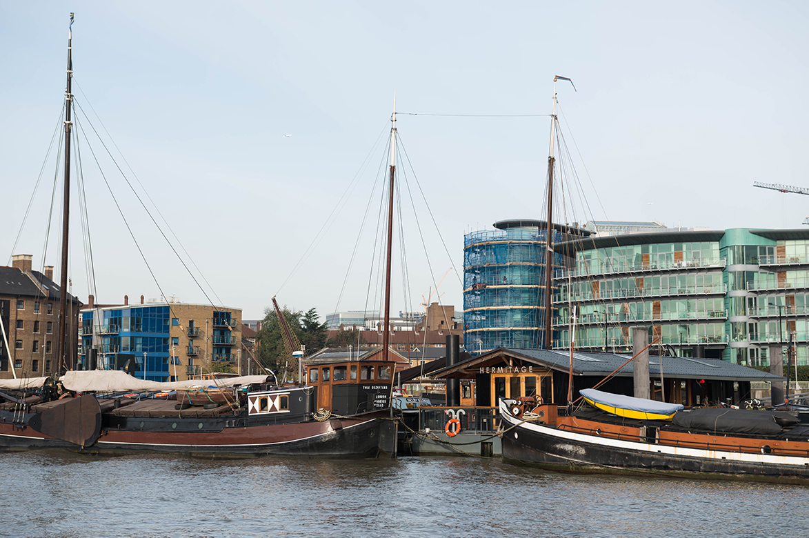 Moorings add to the vibrancy and diversity of the character of the Thames. |
In addition, any development proposals including moorings must ensure that they are designed in such a way that respects their local character, environment and biodiversity, particularly if the proposed development is located within or in close proximity to a Conservation Area or other designated heritage asset. This is particularly important for the access between marine and landside development and should be set out in associated Design and Access Statements and/or heritage or characterisation assessments.
The Maritime and Coastguard Agency classify the tidal Thames as Category C waters where wave heights of up to 1.2 metres may be expected- this needs to be taken into account as part of any moorings proposals. Turbulent waters (wash) from passing vessels can at times create issues for residential moorings. The amount of wash will dictate the type of mooring and vessels that are suitable in a specific area and can also help to ensure that river operations are not negatively affected. Therefore, it is essential that all mooring infrastructure, including wash mitigation measures, are clearly set out as part any planning application and it is advisable to consult with the PLA on this at an early stage.
In addition, any development proposals including moorings must ensure that they are designed in such a way that respects their local character, environment and biodiversity, particularly if the proposed development is located within or in close proximity to a Conservation Area or other designated heritage asset. This is particularly important for the access between marine and landside development and should be set out in associated Design and Access Statements and/or heritage or characterisation assessments.
7. Design Guidance – Environment and Safety
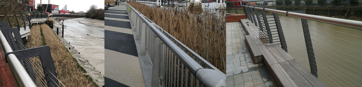 A Safer Riverside provides examples of best practice. |
A Safer Riverside
In addition to the A Safer Riverside guidance highlighted earlier, the PLA, along with other organisations including the RNLI and emergency services produced the Drowning Prevention Strategy (2019) which sets out to ensure that safety is an intrinsic part of future development. Development proposals must show how suicide prevention measures (such as CCTV and signage with information to access support) have been considered and this should be supported by appropriately worded planning conditions.
The Tidal Thames Water Safety Forum have also recently published the Riverside Community Water Safety Guide to provide advice on enjoying the river safely for all those living or working in properties near the river. It is recommended that this guide is provided as part of any ‘welcome packs’ for new residents moving into a riverside development.
Habitat enhancement and improvements
For development proposals with a riverside edge, the Design and Access Statement and/or Landscape Strategy, must consider the impact of the development on the river environment and address enhancements through mitigation or compensatory habitat. Information on how to provide this is available via Estuary Edges guidance.
Development proposals should also seek to identify any potential opportunities to promote river bank restoration and improve water quality and the foreshore in line with strategic planning policy. Under the Environment Act 2021, all planning permissions granted in England (with a few exemptions) will have to deliver at least 10% biodiversity net gain including in intertidal habitats by 2023 and the PLA is developing an approach to the implementation of Biodiversity Net Gain so it provides appropriate benefits to the tidal Thames and stakeholders.
Waste management
As part of the construction stage of a development it is essential that there are appropriate waste management plans in place to prevent materials from falling into the tidal Thames. Measures may include covering skips or building materials to stop waste products escaping, reducing the number of single-use items used in a project, and consideration of alternative materials. These measures should be included within CEMPs secured through planning conditions.
Lighting
It is important that any proposed external lighting located adjacent or on the river is appropriately designed to ensure that are no negative effects on ecology or navigation. Associated lighting strategies must ensure that these points have been considered and have helped inform the design of any external lighting proposals. Appropriately worded planning conditions that set the detailed lighting scheme must set out how the proposed external lighting will not cause a negative effect on river ecology and/or navigation.
Green technologies on river structures
For development proposals located on or over the river, it is important that the utilisation of green technologies has been fully considered to reduce local impacts, make operational savings, reduce maintenance, secure energy supplies and reduce carbon footprint.
There are four types of renewable energy which are particularly suited to river structures on the Thames: solar, wind, river source heat and tidal energy which can contribute to security of energy supply, provide a cushion against energy price rises and contribute to a reduction in corporate carbon footprint. Proposals should consider other forms of energy efficient green technologies, including shore power to allow vessels to connect to the electrical grid when alongside to avoid running their engines / generators. This would minimise emissions from vessels and related land-side infrastructure, reducing air pollution.
As part of the PLA’s river works licencing process, all applications must include consideration of the use of green technologies and this should also be reflected in energy and sustainability statements provided as part of a detailed planning application. Further information on this requirement can be found here.
Climate resilience
Flood defences are the responsibility of the riparian landowner. The Environment Agency (EA) issue Environmental Permits (formerly Flood Defence consent) on the tidal Thames for developments on the river or works within a relevant distance from the bank or flood defence structure. Please consult the EA for further information. For works near an ordinary watercourse, the local council or internal drainage board can advise if land drainage consent is needed.
The Thames Estuary 2100 Plan (T2100) is an important consideration which aims to; manage the risk of flooding to people, property and the environment, adapt to the challenges of climate change, ensure sustainable and resilient development in the floodplain, protect the social, cultural and commercial value of the tidal Thames, tributaries and floodplain, and enhance and restore ecosystems and maximise benefits of natural floods. The TE2100 plan is currently undergoing review, with an updated plan due to be published in 2022 which will reflect on the improved understanding of climate change impacts, introduce better ways of working, increase access to the river, create habitat, support sustainable and resilient development, and enhance the quality of life of people living around the Thames Estuary.
|
Future Technologies The PLA also has guidance on the following:
|
Radar infrastructure
Across the tidal Thames the PLA owns and operates a network of 15 radars overseeing the river. Data from these radars is transmitted via microwave links to the PLA’s Vessel Traffic Centres at Gravesend and the Thames Barrier and provide a full picture of all shipping movements to and from the river and the outer estuary and it is vital that such infrastructure is protected. Development proposals adjacent to the river, particularly including tall buildings must contact the PLA at an early stage to confirm whether there are any radar links in the vicinity of the development, and if so, what measures need to be put in place to ensure these links can continue to operate.
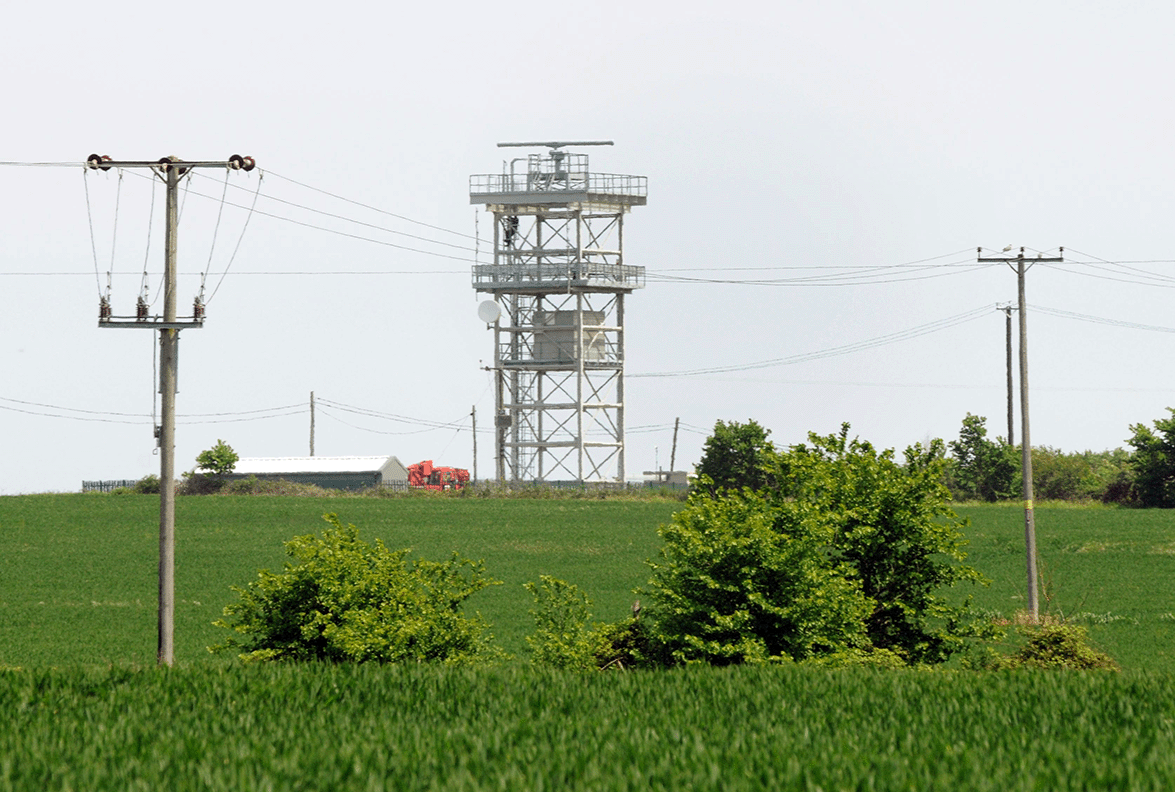 PLA radar facility at All Hallows. |
8. River Works Licensing
A river works licence is required from the PLA for any works in, under or over the Thames. See our licensing site for further information. Where a river works licence is required in addition to planning consent, an informative should be added to the planning permission, highlighting this requirement.
The information required to support each type of RWL application is detailed on the PLA’s website. This includes overlaying any structures proposed in/over the river on a PLA chart, available here. It is recommended that the overlaid chart is also provided with the planning application, to allow for detailed PLA comments to be provided.
 The PLA licenses works that are proposed in / over the river. |
The PLA also licences dredging activities, including both capital and maintenance dredging on the tidal Thames. A development proposal may include dredging for example through the removal of material to enable a pile to be cut off below the riverbed or for a new structure to be installed. Further information can be found here. With regard to maintenance dredging near protected sites, the PLA undertakes a strategic assessment called a Baseline Document, which is required by Natural England. This provides operators with an assessment for their maintenance that takes into account the combined effects of the dredging activity.
As a harbour authority the PLA also has legal requirements to see the full outcomes and analysis of Water Framework Directive Assessments and Appropriate Assessments in order to consent construction or activities. Further information on this can be found here.
9. Other Consents
In addition to planning and PLA consents, consent from other statutory bodies may be required when placing or carrying out works in the Thames including:
- An Environmental Permit from the EA.
- A Marine Licence from the Marine Management Organisation (MMO).
- Natural England consent for works on a protected site.
10. Additional Information
- PLA Environmental Guidance
- PLA guidance on climate change & Greenhouse gases
- Passenger Transport: Achieving Safe and Sustainable Growth of River Transport (2020)
- Thames Vision 2050
Glossary
Air Quality Assessment
An air quality assessment forms a description of baseline conditions and any air quality concerns affecting the area, and how these could change both with and without the proposed development. The assessment should include consideration of sensitive habitats, the basis for assessing impacts and determining the significance of an impact; cumulative effects, construction phase impacts and a recommendation of acceptable mitigation measures to reduce or remove adverse effects.
Agent of Change principle
The principle places the responsibility of mitigating the impact of nuisances (including noise) from existing nuisance generating uses on proposed new development close by, thereby ensuring that residents and users of the new development are protected from nuisances, and existing uses are protected from nuisance complaints. Similarly, any new nuisance-generating development, for example a music venue, will need to put in place measures to mitigate noise impacts on existing development close by.
Biodiversity Net Gain
Biodiversity Net Gain is an approach to development that leaves biodiversity in a better state than before. When applying biodiversity net gain principles, developers are encouraged to bring forward schemes that provide an overall increase in natural habitat and ecological features. The aim of Biodiversity Net Gain is to minimise losses of biodiversity and help to restore ecological networks.
Carbon Footprint
A carbon footprint is defined as the total amount of greenhouse gases produced to directly and indirectly support human activities, usually expressed in equivalent tons of carbon dioxide (CO2).
Category C Waters
Tidal rivers, estuaries and large, deep lakes and lochs where the significant wave height could not be expected to exceed 1.2 metres at any time.
Conservation Areas
Local planning authorities are obliged to designate as conservation areas any parts of their own area that are of special architectural or historic interest, the character and appearance of which it is desirable to preserve or enhance. A conservation area designation introduces a general control over the demolition of unlisted buildings and provides a basis for planning policies whose objective is to conserve all aspects of character or appearance, including landscape and public spaces.
Construction, Environmental Management Plan (CEMP) or Construction Management Plan (CMP)
A plan which sets out details for how a proposal will be developed to avoid, minimise or mitigate any construction effects on the environment, particularly through the use of sustainable transport modes.
Construction Logistics Plan (CLP)
A CLP generally focuses specifically on construction supply chains and how in the construction stage of a development proposal impacts on the road network can be reduced.
Delivery and Servicing Plan (DSP)
A plan that sets out how building occupiers will enable safe, clean and efficient deliveries to/from their site.
Design and Access Statement
A statement that accompanies a planning application to explain the design principles and concepts that have informed the development and how access issues have been dealt with. The access element of the statement should demonstrate how the principles of inclusive design have been integrated into the proposed development and how inclusion will be maintained and managed.
Energy hierarchy
The Mayor of London’s tiered approach to reducing carbon dioxide emissions in the built environment. The first step is to reduce energy demand (be lean), the second step is to supply energy efficiently (be clean) and the third step is using renewable energy (be green).
Environmental statement
This statement will set out a developer’s assessment of a project’s likely environmental effects, submitted with the application for consent for the purposes of the Town and Country Planning (Environmental Impact Assessment) (England and Wales) Regulations 1999.
Freight
A general term to refer to trips made for the purposes of delivering goods, enabling servicing activity or supporting construction.
Habitable room
A habitable room is any room used or intended to be used for sleeping, cooking, living or eating purposes. Enclosed spaces such as bath or toilet facilities, corridors, hallways, utility rooms or similar should not be considered habitable rooms.
Heritage assets
Valued components of the historic environment. They include buildings, monuments, sites, places, areas or landscapes positively identified as having a degree of historic significance meriting consideration in planning decisions. They include both designated heritage assets and non-designated assets where these have been identified by the local authority (including local listing) during the process of decision-making or plan making.
Landscape Strategy
The landscape strategy will include a detailed plan of the site, which will specify the hard and soft landscaping elements that will be included in the project. The strategy should present how the development will manage, monitor, maintain and where necessary remediate landscaped areas within the Development and will be aligned with associated any required ecological mitigation and enhancement measures.
Last Mile Logistics
Last mile logistics refers to the final step of the delivery process from a distribution centre or facility to the end-user.
Lighting Strategy
A lighting strategy should be sent with applications for developments that include the installation of external lighting and should include a description of the proposed hours of operation, light spillage, light levels and column heights, a layout plan of the proposed development site showing beam orientation, details of the proposed equipment design and the expected impact on neighbouring properties and roads. The strategy should also include detail on any proposed measures to mitigate or compensate for the possible impacts of the proposed development on the surrounding area, for example through screening.
Navigational Risk Assessment (NRA)
An NRA should present the activities and assessments undertaken to identify the navigational issues and prepare a risk assessment to be able to assess any navigational risks and identify mitigation measures for the development proposal.
Noise and/or vibration assessments
A noise impact assessment is a type of survey that is often necessary in determining what is feasible for a particular location in terms of noise tolerance. The assessment of a noise or vibration effects may be via measurements of existing noise and/or vibration, or prediction, calculation and modelling of proposed noise and/or vibration sources. The results of the assessment are compared to local and national legislation in order to determine if the planning application complies with regulations. If this is the case then it will normally mean that there will not be an issue however if the evaluation shows that impacts will exceed the levels allowed within regulations, then it will be necessary for these impacts to be mitigated, and the assessment must clearly set out the required detailed mitigation measures.
PLA Chart
The PLA publishes charts from Teddington to Southend that should be used as part of any proposals within the Tidal Thames area. These are available at https://www.pla.co.uk/Safety/PLA-Hydrographic-Service-Published-Surveys.
Ramsar Site
Nature conservation site designated under the Convention on Wetlands of International Importance 1971.
Safeguarded Wharves
A network of sites that have been safeguarded for cargo handling uses such as intraport or transhipment movements and freight-related purposes by Safeguarding Directions. A site remains safeguarded unless and until the relevant Safeguarding Direction is formally removed or amended.
Section 106 agreements
These agreements confer planning obligations on persons with an interest in land in order to achieve the implementation of relevant planning policies as authorised by Section 106 of the Town and Country Planning Act 1990.
Site of Importance for Nature Conservation (SINC)
Areas of land chosen to represent the best wildlife habitats in London and areas of land where people can experience nature close to where they live and work. Sites are classified into Sites of Metropolitan, Borough and Local Importance depending on their relative value. Unlike SSSIs (see below), SINCs are not legally protected, but their value must be considered in any land use planning decision. Procedures for the identification of SINCs are set out in Appendix 5 of the Mayor’s London Environment Strategy.
Site of Special Scientific Interest (SSSI)
Areas of land with ecological or geological interest of national importance. They are designated by Natural England under the Wildlife and Countryside Act (1981 as amended) and have legal protection.
Sustainability & Energy Statement
Required as part of development proposals to demonstrate how improved energy performance will be achieved as part of the scheme, and should show how consideration of fabric performance, renewable technologies and efficient and clean building services have been fully taken into account.
Thames Path
The Thames Path is a National Trail following the River Thames from its source near Kemble in Gloucestershire to the Thames Barrier at Charlton, south east London, covering areas both north and south of the River Thames.
Transport Assessment
This is prepared and submitted alongside planning applications for developments likely to have significant transport implications. For major proposals, assessments should illustrate the following: accessibility to the site by all modes; the likely modal split of journeys to and from the site; and proposed measures to improve access by public transport, walking and cycling.
Travel Information Pack
The information pack provided to each employee / resident of a new development which should include information on nearby public transport routes and timetables, walkways and cycleways in and around the development.
Travel Plan
The primary purpose of a Travel Plan is to identify opportunities for the effective promotion and delivery of sustainable transport initiatives e.g.: walking, cycling and public transport modes including river based transport, in connection with both proposed and existing developments and through this set out how to reduce the demand for travel by less sustainable modes.
